Project Area
There are eight projects in total. Using the navigation bar to your left you can select each project to find out more about it, and to answer some questions relating to it. If you're completing this survey on a phone, the navigation bar will be in a drop-down menu at the top of your screen. Please give your thoughts and feedback on as many proposals as you like, but we encourage everyone to also complete the general questions at the start of the survey as well.
We encourage you to take your time, as some of the questions are quite specific. Answering questions in each section will take approximately 3 minutes.

- 1
Transforming Anniesland Road
- 2
Dumbarton Road, Anniesland Road, Kingsway and Burnham Road Junction
- 3
Transforming Victoria Park Drive South
- 4
Dumbarton Road and Victoria Park Drive South Junction
- 5
Scotstoun Neighbourhood Filtered Permeability
- 6
Transforming Jordanhill School Access
- 7
Better Railway Crossings: Hawick Street
- 8
Transforming Dumbarton Road
General questions
We want to understand your general preferences on public space and its use, so that we can consider this when looking at the proposed improvements in greater detail. Across the proposed improvements, there may also be scope to include additional features. Understanding your preferences can help us prioritise these. These are just general questions and there will be opportunities in the later questions on each proposal itself to give us more specific thoughts.
Questions
Transforming Anniesland Road
Improvements to the streetscape of western Anniesland Road to improve the walking and cycling accessibility and enhance the street’s appearance.
Anniesland Road is an important movement route for all modes of travel but is dominated by vehicles. There is a wide space available along the street but most of this is given over to vehicles, with a wide carriageway allowing vehicles to travel fast. There are few crossing points and the side roads junctions can be difficult to cross, particularly Cairntoul Drive. Knightswood Centre is an important destination but is difficult for people to access. The shops at the southern end of Anniesland Road have unsafe parking outside. The junction with Kingsway is very wide and vehicles can turn at fast speeds making it hard for pedestrians to cross.
We are proposing an ambitious plan to address the section of Anniesland Road from Dumbarton Road to Kingsway, passing by Knightswood Shopping Centre. The proposals include changes to movement across the railway bridge at Crescent Road making more space for pedestrians.
We have two options for this proposed improvement, with one offering a more ambitious provision of public space for the area. We will first show you the whole scheme for Option 1 overall, and then zoom in to specific areas for it; we will then show you Option 2 after this.
Proposed Improvements - Option 1


The public said...
There could be better pedestrian connectivity between areas around Anniesland Road, Kingsway and Knightswood Shopping centre.
There could be better connectivity across the railway to the North.
The pedestrian experience throughout this area is disjointed, indirect and crosses a number of major roads with poor crossing points.
Using a bike in this area does not feel safe or easy to navigate.
Accessibility throughout this area could be improved, to make moving through it better for all ages and bodies.
Key design features:
- Reducing level changes and improving the directness of the existing route by considering options for an at-grade route alongside Viewpark Avenue; or alternatively a raised facility, utilising the existing bridges and ramps.
- Considering the possibility of reopening the closed raised walkway beneath the M8, potentially on a trial basis initially.
- Improve the quality of the route by maintaining / improving planting and vegetation, and considering opportunities for public art, lighting improvements and wayfinding information.
Current situation

Proposed Improvements

Questions
Current situation

Proposed Improvements

Current situation

Proposed Improvements

Questions
Proposed Improvements - Option 2

Questions
Dumbarton Road, Anniesland Road, Kingsway and Burnham Road Junction
Redesign of the existing junction to simplify and improve pedestrian and cycle crossings, route legibility, and accessibility of all movements and aligned to key desire lines.
Existing condition

The public said...
The junction is a very busy and hostile environment for pedestrians and cyclists.
Some pavements are narrow, and crossings can be difficult to use or aren’t aligned with pedestrian routes.
The Kingsway junction allows vehicles to turn at speed but does not have any crossing facilities.
National Cycle Network Route 7 crosses the junction on the old railway bridge but it is not obvious how to get to this route.
The environment under the bridge could be better and feel safer at night.
Proposed improvements

Key design features:
- Improvements to pedestrian crossings with new signalised crossings provided at desire lines.
- Junction tightening and footway widening.
- Improvement of public realm.
- Potential closure of Kingsway to through-traffic.
- Removal of guardrailings and improvements to street furniture.
- Improvements to environment under overpass bridge.
- Explore improved access to Cycle Network.
Questions
Transforming Victoria Park Drive South
Transformation of the road corridor into a people-friendly street that reduces severance between Whiteinch and Victoria Park.
Existing condition

The public said...
The design of the road means that it is very difficult for people in Whiteinch to access Victoria Park.
The existing underpasses are too steep and feel unsafe, particularly at night.
The wide road encourages drivers to speed, making the street feel unsafe and affects how people can enjoy the park.
There is no pavement along the edge of the park and no safe cycle route towards the city centre.
There could be a much better interface between the park and Whiteinch Library.
Proposed improvements

Key design features:
- Downgrade to single carriageway, with significant environmental enhancement to create an avenue.
- Infill underpasses, replace with at-grade crossings.
- Extension of southern footway to Dumbarton Road.
- Planting improvements on existing verges and removal of guardrailings.
- Improvement to appearance of park entrances.
- Improvement to bus facilities.
- Cycle route connecting into the park, Nature Walk and into the City Network.
- Improvements to pedestrian amenity at Westland Drive junction and at side roads.
Questions
Dumbarton Road and Victoria Park Drive South Junction
Redesign of the existing junction to simplify and improve pedestrian and cycle crossings, route legibility, and accessibility of all movements aligned to key desired lines.
Existing condition

The public said...
Roads are busy and accessibility for pedestrians is very poor.
The pedestrian crossing on Dumbarton Road has two stages and requires many pedestrians to detour to use it.
There is no crossing facility for eastern Dumbarton Road and no crossing or footway for Victoria Park Drive South.
There is a large amount of guardrailing making the area feel hostile.
There is empty space that could be repurposed to provide space for people and improvements to the appearance of the area.
It can be difficult for vehicles to turn out of Dumbarton Road, causing delays to bus journeys.
Proposed improvements

Key design features:
- Improvement to pedestrian crossing amenity with signalised crossings provided.
- Junction tightening and footway widening.
- Improvement of public realm around local centre.
- Removal of guardrailings and improvements to street furniture.
- Improvements to vehicle and cycle parking at local centre.
- Improved connectivity to Cycle Network via Methil Street.
Questions
Scotstoun Neighbourhood Filtered Permeability
Roll-out of a ‘filtered permeability’ to address ‘rat-running’ in the Scotstoun neighbourhood and create greater amenity for local residents.
Existing condition

The public said...
“The main roads surrounding Scotstoun can get very busy at peak times and people choose to drive through the Scotstoun neighbourhood as a shortcut.
Vehicle traffic particularly needs to be kept away from Scotstoun Primary School to create a safer environment for pupils and parents.
Some junctions are poorly designed for pedestrians and can be difficult to cross.
Pavement parking blocks routes for pedestrians.
Rainwater drainage is poor and the streets can be blocked by large puddles.
Proposed improvements
To reduce through-traffic and calm traffic through the Scotstoun area, we have developed a number of initial ideas on how this could be achieved. Alongside the general strategy for reducing ‘rat running’, these ideas have a number of potential solutions which focus separately on:
- junctions along the major roads surrounding the area,
- the inner junctions of the area
- the streets within the areas, including around Scotstoun Primary School.
The following questions will allow you to give your general thoughts on the strategy, and also help us in preferencing which of the different strategies could be most effective.
1. Movement Scenarios
The diagrams below represent a variety of movement scenarios for changing how one would navigate the internal streets of Scotstoun with a vehicle. These scenarios would prevent drivers from rat-running, making the internal streets in Scotstoun used mostly by residents only and safer for people walking, wheeling and using their bike. It would also support safer access to Scotstoun Primary School.


Questions
2. Boundary Road Junctions
The diagrams below represent approaches to reduce the amount of non-local traffic entering the Scotstoun avenues area. These approaches would prevent rat-running and facilitate people walking, wheeling and using a bike.


Questions
3. Internal Junctions
The diagrams below represent a variety of approaches to inner junctions within the area, which would prevent rat-running and facilitate residents’ navigation of the area for pedestrians and on bikes.


Questions
4. Street Enhancements
The diagrams below represent types of street enhancement which would help reduce speeds and calm traffic. These would put people first, making the neighbourhood feel safer and less vehicle-dominated.


Questions
Transforming Jordanhill School Access
Streetscape enhancements to improve safety and amenity for school pupils and residents. This may include reallocating space to provide more space for people and less for vehicles, slowing traffic and providing better control of traffic.
Existing condition
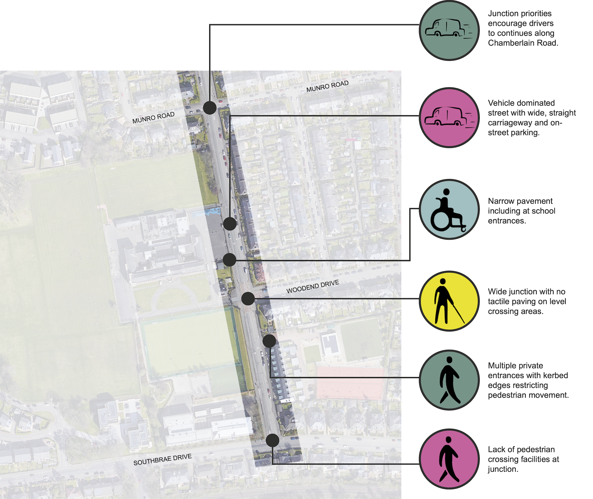
The public said...
Chamberlain Road is a very wide street for the amount of traffic it carries, allowing vehicles to speed past the school and encouraging people to use it as a rat-run.
Pedestrians have narrow pavements and no crossing points.
There is little space for people to gather around the entrances of Jordanhill School and the street environment is unappealing with no street trees or planting.
There are multiple private accesses with kerbed edges that can be difficult for people to cross.
Heavy rain brings large puddles which makes the pavement difficult to use.
Proposed improvements

Key design features:
- Carriageway narrowing, including at the junction with Southbrae Drive.
- Redesign of side road junctions, with potential for continuous footways.
- Installation of a pedestrian crossing.
- Redesign of vehicle entrances to the school.
- Improvements to greenery including additional planting and rain gardens for sustainable drainage.
- Re-allocation of parking along the street.
- New palette of street furniture.
- School Street access restrictions at school peak hours.
Questions
Better Railway Crossings: Hawick Street
Improvements to walking and cycling accessibility and personal safety along Hawick Street, connecting communities and facilities, and improving routes to local schools north of the railway line.
To help achieve the goals of this proposed improvement, we have developed three potential options. It is important to note that Mill Road, Dyke Road and Kelso Street will remain usable for through-traffic, pedestrians and people on bikes. Kelso Street see improvements separately as part of the City Network and Dyke Road has recently had improvements to cycle provision. Mill Road lies on the border between Glasgow and West Dunbartonshire and is more complicated to improve.
Existing condition

The public said...
Hawick Street, Dyke Road and Kelso Street are valuable walking and cycling routes for people crossing the railway to local schools and to Dumbarton Road.
The street suffers from narrow pavements and pavement parking.
Vehicles travel fast across the railway bridge and there are no safe points to cross.
Proposed improvements
Key design features:
- Widening of footway, particularly at bridge.
- Use of build-outs to control parking and facilitate pedestrian crossing.
- Improvement to pedestrian amenity at side roads and private access crossings.
- Explore potential to close road through-traffic, creating a quiet street for walking and cycling.
- Provision of wayfinding scheme.
Scenario A

Scenario B

Scenario C

Questions
Transforming Dumbarton Road
Area-wide programme of junction and street redesigns to make it easier and safer to cross the road.
This project will develop a set of enhanced junction designs to be adapted and applied at junctions across the improvement area. This can potentially be used as a pilot project for the wider city.
Existing condition

The public said...
The junctions are not well designed for pedestrians and cyclists.
Many junctions do not have the tactile paving needed by blind and partially sighted people.
Junctions lack dropped kerbs and have level changes that can be difficult for people to get across, especially using wheelchairs.
Junctions are very wide or have sweeping corners meaning that vehicles can drive in at high speeds and people have a long distance to cross.
Cars are often parked right up to the junction, meaning that pedestrians and drivers cannot see each other.
Proposed improvements

Key design features:
- Narrowing and simplification of side road junctions with build-outs to control parking.
- Removal of surplus filter lanes.
- Improvement to pedestrian crossings, with signalised crossings on major junctions and potential for continuous footways.
- Potential use of rain gardens to control surface water at junctions.


Questions
Equalities Monitoring
We have a few more questions...
We would be grateful if you could tell us about yourself! This data is collected for equalities monitoring purposes*. Answers to these questions are anonymous.
*Personal information will be processed in line with our Privacy Policy.